
The first article in the Climate Risk series
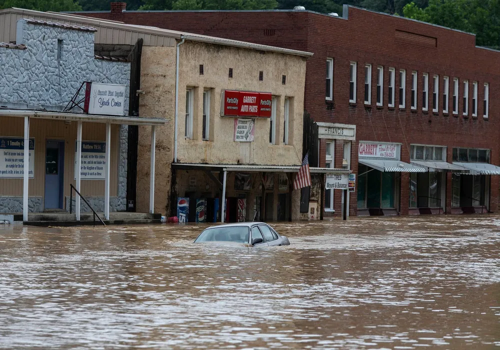
As we’ve seen recently, climate change can cause precipitation to “bunch up” and rain or snow in large amounts in a short period of time. Factors such as property level, proximity to rivers or bodies of water, infrastructure, and past flooding can all contribute to the risk of a given location.
The First Street Flood Factor model “incorporates the four major contributors to flooding: tidal, rain, riverine and storm surge. By taking property level data, overlaying building footprints, and applying the flood hazard layers, it calculates the max depth of flood water reaching the building or center of an empty lot.”
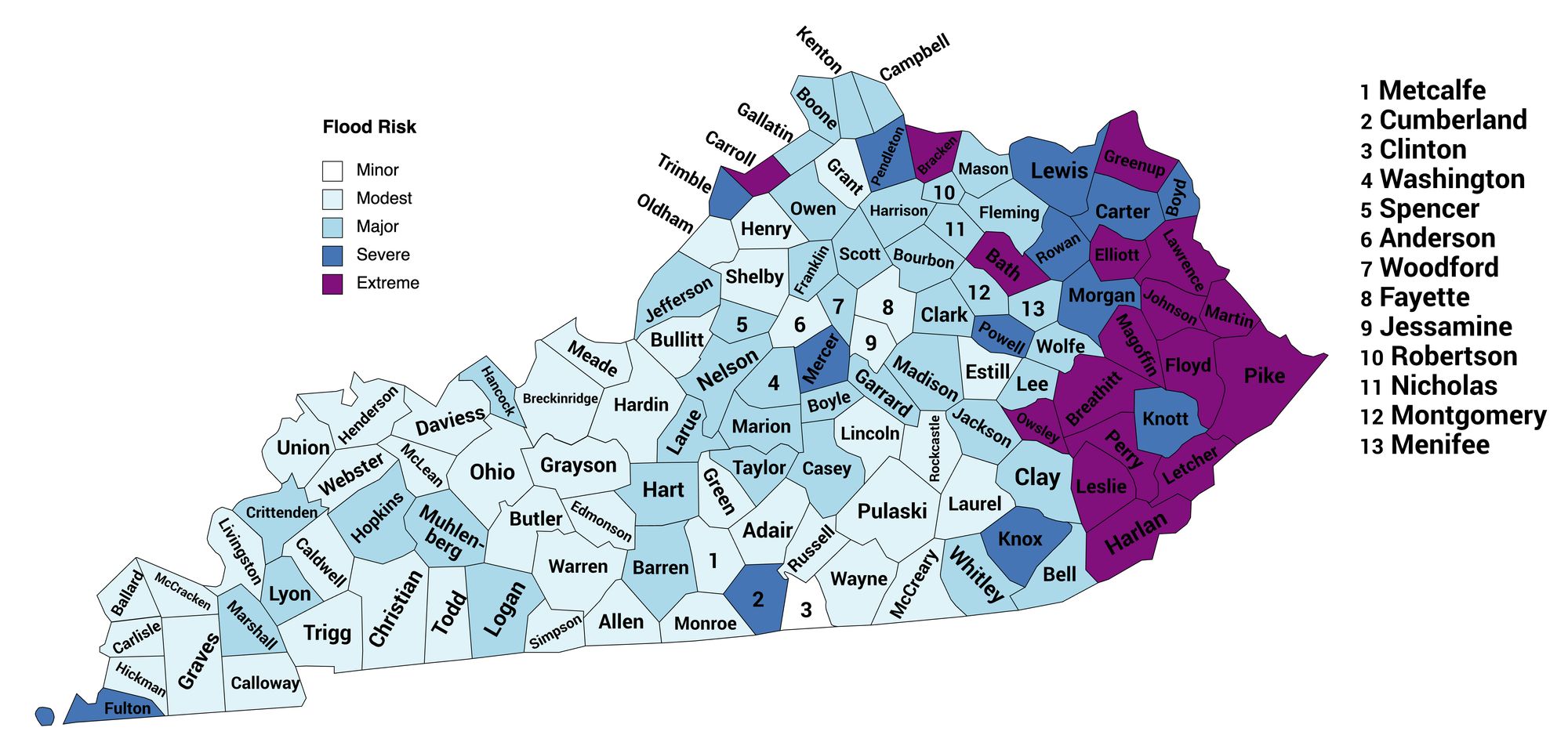
The flooding risks by county are rated as follows:
1 = minor risk
2 = modest risk
3 = major risk
4 = severe risk
5 = extreme risk
Based on this risk rating, here is a map of the flood risk by county across the state:
Map of Flood Risk across Kentucky
Flood Risk Data Table
And here is a table of the underlying data. You can sort the table by clicking on a column header.
| County | Flood Risk |
|---|---|
| Clinton | 1 |
| Adair | 2 |
| Allen | 2 |
| Anderson | 2 |
| Ballard | 2 |
| Breckinridge | 2 |
| Bullitt | 2 |
| Butler | 2 |
| Caldwell | 2 |
| Calloway | 2 |
| Carlisle | 2 |
| Christian | 2 |
| Daviess | 2 |
| Edmonson | 2 |
| Estill | 2 |
| Fayette | 2 |
| Grant | 2 |
| Graves | 2 |
| Grayson | 2 |
| Green | 2 |
| Hardin | 2 |
| Henderson | 2 |
| Henry | 2 |
| Hickman | 2 |
| Jessamine | 2 |
| Laurel | 2 |
| Lincoln | 2 |
| Livingston | 2 |
| McCracken | 2 |
| McCreary | 2 |
| McLean | 2 |
| Meade | 2 |
| Metcalfe | 2 |
| Monroe | 2 |
| Ohio | 2 |
| Oldham | 2 |
| Pulaski | 2 |
| Rockcastle | 2 |
| Russell | 2 |
| Shelby | 2 |
| Simpson | 2 |
| Todd | 2 |
| Trigg | 2 |
| Union | 2 |
| Warren | 2 |
| Wayne | 2 |
| Webster | 2 |
| Barren | 3 |
| Bell | 3 |
| Boone | 3 |
| Bourbon | 3 |
| Boyle | 3 |
| Campbell | 3 |
| Casey | 3 |
| Clark | 3 |
| Clay | 3 |
| Crittenden | 3 |
| Fleming | 3 |
| Franklin | 3 |
| Gallatin | 3 |
| Garrard | 3 |
| Hancock | 3 |
| Harrison | 3 |
| Hart | 3 |
| Hopkins | 3 |
| Jackson | 3 |
| Jefferson | 3 |
| Kenton | 3 |
| Larue | 3 |
| Lee | 3 |
| Logan | 3 |
| Lyon | 3 |
| Madison | 3 |
| Marion | 3 |
| Marshall | 3 |
| Mason | 3 |
| Menifee | 3 |
| Montgomery | 3 |
| Muhlenberg | 3 |
| Nelson | 3 |
| Nicholas | 3 |
| Owen | 3 |
| Robertson | 3 |
| Scott | 3 |
| Spencer | 3 |
| Taylor | 3 |
| Washington | 3 |
| Whitley | 3 |
| Wolfe | 3 |
| Woodford | 3 |
| Boyd | 4 |
| Carter | 4 |
| Cumberland | 4 |
| Fulton | 4 |
| Knott | 4 |
| Knox | 4 |
| Lewis | 4 |
| Mercer | 4 |
| Morgan | 4 |
| Pendleton | 4 |
| Powell | 4 |
| Rowan | 4 |
| Trimble | 4 |
| Bath | 5 |
| Bracken | 5 |
| Breathitt | 5 |
| Carroll | 5 |
| Elliott | 5 |
| Floyd | 5 |
| Greenup | 5 |
| Harlan | 5 |
| Johnson | 5 |
| Lawrence | 5 |
| Leslie | 5 |
| Letcher | 5 |
| Magoffin | 5 |
| Martin | 5 |
| Owsley | 5 |
| Perry | 5 |
| Pike | 5 |
Notes and Conclusions
Looking at the map, it is obvious that the eastern part of the state is most at risk from flooding due to climate change. And, as anyone familiar with Kentucky knows, it is an area of the state least able to deal with the risk.
We tend to think of weather-related natural disasters as one-off events. Thus, the description of something as a “100-year flood.”
The problem is that 100- or 500-year events are going to become 50-, 20-, or even 10- or 5-year events. What would eastern Kentucky do if another massive rain event caused flooding in the same counties already inundated last year?
We must help our counties in the east to begin preparing now for the changes coming due to climate change. It’s a government-level problem, and government has to step up.
--30--
|
Comments


